‘Indian Rivers Map’ PDF Quick download link is given at the bottom of this article. You can see the PDF demo, size of the PDF, page numbers, and direct download Free PDF of ‘Indian Rivers Systems’ using the download button.
Indian/Bharat Rivers Map Book PDF Free Download
Indian/Bharat Rivers Map And Rivers Systems PDF
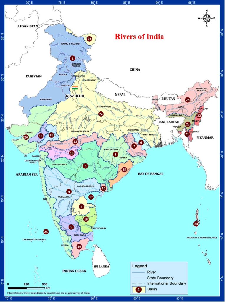
| Code | Basin Name |
| 1 | Indus (Up to border) |
| 2a | Ganga |
| 2b | Brahmaputra |
| 2b | Barak and others |
| 3 | Godavari |
| 4 | Krishna |
| 5 | Cauvery |
| 6 | Subernarekha |
| 7 | Brahmani and Baitarni |
| 8 | Mahanadi |
| 9 | Pennar |
| 10 | Mahi |
| 11 | Sabarmati |
| 12 | Narmada |
| 13 | Tapi |
| 14 | West flowing rivers South of Tapi |
| 15 | East flowing rivers between Mahanadi and Godavari |
| 16 | East flowing rivers between Godavari and Krishna |
| 17 | East flowing rivers between Krishna and Pennar |
| 18 | East flowing rivers between Pennar and Cauvery |
| 19 | East flowing rivers South of Cauvery |
| 20 | West flowing rivers of Kutch and Saurashtra including Luni |
| 21 | Minor rivers draining into Bangladesh |
| 22 | Minor rivers draining into Myanmar |
| 23 | Area of North Ladakh not draining into Indus |
| 24 | Drainage Area of Andaman & Nicobar Islands |
| 25 | Drainage Area of Lakshadweep Islands |
| Author | – |
| Language | English |
| Pages | 3 |
| PDF Size | 1.70 MB |
| Category | Government |
Himalayan Rivers
The main Himalayan river systems are the Ganga, the Indus, and the Brahmaputra river systems. The Himalayan rivers form large basins. Many rivers pass through the Himalayas. These deep valleys with steep rock sides were formed by the down-cutting of the river during the period of the Himalayan uplift.
They perform intense erosional activity up the streams and carry a huge load of sand and silt. In the plains, they form large meanders, and a variety of depositional features like flood plains, river cliffs, and levees.
These rivers are perennial as they get water from the rainfall as well as the melting of ice. Nearly all of them create huge plains and are navigable over long distances of their course. These rivers are also harnessed in their upstream catchment area to generate hydroelectricity.
Peninsular Rivers
The main peninsular river systems include the Narmada, the Tapi, the Godavari, the Krishna, the Kaveri and the Mahanadi river systems. The Peninsular rivers flow through shallow valleys.
A large number of them are seasonal as their flow is dependent on rainfall. The intensity of erosional activities is also comparatively low because of the gentler slope.
The hard rock bed and lack of silt and sand do not allow any significant meandering. Many rivers, therefore, have straight and linear courses. These rivers provide huge opportunities for hydroelectric power.
The Indus River System
The Indus originates in the northern slopes of the Kailash range in Tibet near Lake Manasarovar. It follows a north-westerly course through Tibet. It enters Indian territory in Jammu and Kashmir.
It forms a picturesque gorge in this part. Several tributaries – the Zaskar, the Shyok, the Nubra and the Hunza join it in the Kashmir region. It flows through the regions of Ladakh, Baltistan and Gilgit and runs between the Ladakh Range and the Zaskar Range.
It crosses the Himalayas through a 5181 m deep gorge near Attock, lying north of the Nanga Parbat and later takes a bend to the southwest direction before entering Pakistan.
It has a large number of tributaries in both India and Pakistan and has a total length of about 2897 km from the source to the point near Karachi where it falls into the Arabian Sea. The main tributaries of the Indus in India are Jhelum, Chenab, Ravi, Beas, and Sutlej.
Jhelum
The Jhelum originates in the southeastern part of Kashmir, in a spring at Verinag. It flows into the Wular Lake, which lies to the north, and then into Baramula. Between Baramula and Muzaffarabad, it enters a deep gorge cut by the river in the Pir Panjal range.
It has a right bank tributary the Kishanganga which joins it at Muzaffarabad. It follows the Indo-Pakistan border flowing into the plains of Punjab, finally joining the Chenab at Trimmu.
Chenab
The Chenab originates from the confluence of two rivers, the Chandra and the Bhaga, which themselves originate from either side of the Bara Lacha Pass in Lahul. It is also known as the Chandrabhaga in Himachal Pradesh. It runs parallel to the Pir Panjal Range in the north-westerly direction and cuts through the range near Kishtwar.
It enters the plains of Punjab near Akhnur and is later joined by the Jhelum. It is further joined by the Ravi and the Sutlej in Pakistan.
Ravi
The Ravi originates near the Rohtang pass in the Kangra Himalayas and follows a north-westerly course. It turns to the southwest, near Dalhousie, and then cuts a gorge in the Dhaola Dhar range entering the Punjab plain near Madhopur.
It flows as a part of the Indo-Pakistan border for some distance before entering Pakistan and joining the Chenab river. The total length of the river is about 720 km.
Beas
The Beas originates in Beas Kund, lying near the Rohtang pass. It runs past Manali and Kulu, where its beautiful valley is known as the Kulu Valley.
It first follows a northwest path from the town of Mandi and later a westerly path, before entering Punjab plains near Mirthal. It joins the Sutlej River near Harika, after being joined by a few tributaries. The total length of the river is 615 km.
Sutlej
The Sutlej originates from the Rakas Lake, which is connected to the Manasarovar lake by a stream, in Tibet. Its flows in a north-westerly direction and enters Himachal Pradesh at the Shipki Pass, where it is joined by the Spiti river.
It cuts deep gorges in the ranges of the Himalayas, and finally enters the Punjab plain after cutting a gorge in a hill range, the Naina Devi Dhar, where the Bhakra Dam having a large reservoir of water, called the Gobind Sagar, has been constructed.
It turns west below Rupar and is later joined by the Beas. It enters Pakistan near Sulemanki and is later joined by the Chenab. It has a total length of almost 1500 km.
The Brahmaputra River System
The Brahmaputra originates in the Mansarovar lake, also the source of the Indus and the Satluj. It is slightly longer than the Indus, but most of its course lies outside India.
It flows eastward, parallel to the Himalayas. Reaching Namcha Barwa (7757 m), it takes a U-turn around it and enters India in Arunachal Pradesh and known as dihang. The undercutting done by this river is of the order of 5500 meters. In India, it flows through Arunachal Pradesh and Assam and is joined by several tributaries.
In Tibet, the river is known as the Tsangpo. There, it receives less volume of water and has less silt. But in India, it passes through a region of heavy rainfall and as such, the river carries a large amount of rainfall and a considerable amount of silt.
The Brahmaputra has a braided channel throughout most of its length in Assam, with a few large islands within the channel.
The shifting of the channels of the river is also very common. The fury of the river during rains is very high. It is known for creating havoc in Assam and Bangladesh. At the same time, quite a few big pockets suffer from drought.
The Narmada River System
The Narmada or Nerbudda is a river in central India. It forms the traditional boundary between North India and South India, and is a total of 1,289 km (801 mi) long. Of the major rivers of peninsular India, only the Narmada, the Tapti and the Mahi run from east to west.
It rises on the summit of Amarkantak Hill in Madhya Pradesh state, and for the first 320 kilometers (200 miles) of its course winds among the Mandla Hills,
which form the head of the Satpura Range; then at Jabalpur, passing through the ‘Marble Rocks’, it enters the Narmada Valley between the Vindhya and Satpura ranges and pursues a direct westerly course to the Gulf of Cambay.
Its total length through the states of Madhya Pradesh, Maharashtra, and Gujarat amounts to 1312 kilometers (815 miles), and it empties into the Arabian Sea in the Bharuch district of Gujarat.
The Tapi River System
The Tapi is a river of central India. It is one of the major rivers of peninsular India with the length of around 724 km, and only the Tapi River along with the Narmada river, and the Mahi River run from east to west.
It rises in the eastern Satpura Range of southern Madhya Pradesh state, and flows westward, draining Madhya Pradesh’s historic Nimar region, Maharashtra’s historic Khandesh, and east Vidarbha regions in the northwest corner of the Deccan Plateau and South Gujarat before emptying into the Gulf of Cambay of the Arabian Sea, in the State of Gujarat.
The Western Ghats or Sahyadri range starts south of the Tapti River near the border of Gujarat and Maharashtra.
The Tapi River Basin lies mostly in northern and eastern districts Maharashtra state viz, Amravati, Akola, Buldhana, Washim, Jalgaon, Dhule, Nandurbar, Malegaon, Nashik districts but also covers Betul, Burhanpur districts of Madhya Pradesh and Surat district in Gujarat as well.
The principal tributaries of Tapi River are Purna River, Girna River, Panzara River, Waghur River, Bori River and Aner River.
The Godavari River System
The river with the second-longest course within India, Godavari is often referred to as the Vriddh (Old) Ganga or the Dakshin (South) Ganga. The name may be apt in more ways than one, as the river follows the course of Ganga’s tragedy. The river is about 1,450 km (900 miles) long.
It rises at Trimbakeshwar, near Nasik and Mumbai (formerly Bombay) in Maharashtra around 380 km distance from the Arabian Sea, but flows southeast across south-central India through the states of Madhya Pradesh, Karnataka, Orissa and Andhra Pradesh, and empties into the Bay of Bengal.
At Rajahmundry, 80 km from the coast, the river splits into two streams thus forming a very fertile delta. Like any other major rivers in India, the banks of this river also has many pilgrimage sites, Nasik, Triyambak and Bhadrachalam, being the major ones.
It is a seasonal river, widened during the monsoons and dried during the summers. Godavari river water is brownish. Some of its tributaries include Indravati River, Pranahita (Combination of Penuganga and Warda), Manjira, Bindusara and Sabari.
Some important urban centers on its banks include Nasik, Bhadrachalam, Rajahmundry and Narsapur. The Asia’s largest rail-cum-road bridge on the river Godavari linking Kovvur and Rajahmundry is considered to be an engineering feat.
The Krishna River System
The Krishna is one of the longest rivers of India (about 1300 km in length). It originates at Mahabaleshwar in Maharashtra, passes through Sangli and meets the sea in the Bay of Bengal at Hamasaladeevi in Andhra Pradesh. The Krishna River flows through the states of Maharashtra, Karnataka and Andhra Pradesh.
The traditional source of the river is a spout from the mouth of a statue of a cow in the ancient temple of Mahadev in Mahabaleshwar.
Its most important tributary is the Tungabhadra River, which itself is formed by the Tunga and Bhadra rivers that originate in the Western Ghats.
Other tributaries include the Koyna, Bhima, Mallaprabha, Ghataprabha, Yerla, Warna, Dindi, Musi and Dudhganga rivers.
The Kaveri River System
The Kaveri (also spelled Cauvery or Kavery) is one of the great rivers of India and is considered sacred by the Hindus. This river is also called Dakshin Ganga.
The headwaters are in the Western Ghats range of Karnataka state, and from Karnataka through Tamil Nadu. It empties into the Bay of Bengal. Its waters have supported irrigated agriculture for centuries, and the Kaveri has been the lifeblood of the ancient kingdoms and modern cities of South India.
The source of the river is Talakaveri located in the Western Ghats about 5,000 feet (1,500 m) above sea level. Talakaveri is a famous pilgrimage and tourist spot set amidst Bramahagiri Hills near Madikeri in Kodagu district of Karnataka.
Thousands of pilgrims flock to the temple at the source of the river, especially on the specified day known as Tula sankramana when the river water has been witnessed to gush out like a fountain at a predetermined time.
It flows generally south and east for around 765 km, emptying into the Bay of Bengal through two principal mouths.
Its basin is estimated to be 27,700 square miles (71,700 km²), and it has many tributaries including Shimsha, Hemavati, Arkavathy, Kapila, Honnuhole, Lakshmana Tirtha, Kabini, Lokapavani, Bhavani, Noyyal and Famous Amaravati.
The Mahanadi River System
The Mahanadi is a river of eastern India. The Mahanadi rises in the Satpura Range of central India and flows east to the Bay of Bengal.
The Mahanadi drains most of the state of Chhattisgarh and much of Orissa and also Jharkhand and Maharashtra. It has a length of about 860 km.
Near the city of Sambalpur, a large dam – the Hirakud Dam – is built on the river.
Related PDFs
North & South America High-Resolution Map PDF
Asia Political & Physical Complete Map PDF
Complete Atlas Map Of The World PDF
World Map Political & Physical Map PDF
Africa Continent Political And Physical Map PDF
Indian/Bharat Rivers Map Book PDF Free Download