‘Maharashtra District Name’ PDF Quick download link is given at the bottom of this article. You can see the PDF demo, size of the PDF, page numbers, and direct download Free PDF of ‘Maharashtra District Map’ using the download button.
Maharashtra District List PDF Free Download

36 Districts In Maharashtra List
There are 36 districts in Maharashtra, divided into 6 administrative divisions. These districts are further divided into sub-districts for better administrative control over the regions.
The Maharashtra districts are divided into the administrative divisions of Konkan, Nashik, Aurangabad, Amravati, Pune, and Nagpur.
We have shared information about the districts in the state of Maharashtra, the total area they cover, and the administrative divisions they fall into here.
How Many Districts in Maharashtra?
Currently, there are 36 districts in Maharashtra. These districts are divided into 6 administrative units headed by a Deputy Commissioner each. Initially, the state of Maharastra was established on 1 May 1960 with only 26 districts. However, in the later years, ten new Maharashtra districts were formed.
You can find the total district in Maharashtra here, with information about the old as well as new districts. In addition, we have also shared the details about the administrative divisions that the districts are put into.
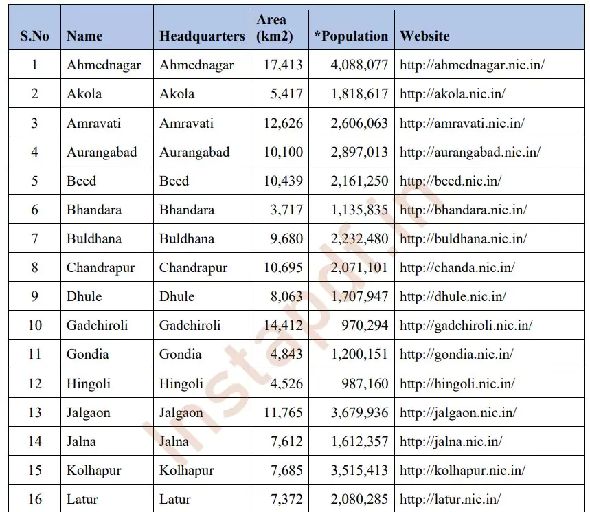
List of Districts in Maharashtra
| S. N. | District Name | Area in sq km | Population of District | Head Quarters Name |
|---|---|---|---|---|
| 1 | Ahmednagar | 17,413 | 4,088,077 | Ahmednagar |
| 2 | Akola | 5,417 | 1,818,617 | Akola |
| 3 | Amravati | 12,626 | 2,606,063 | Amravati |
| 4 | Aurangabad | 10,100 | 2,897,013 | Aurangabad |
| 5 | Beed | 12,703 | 3,116,045 | Beed |
| 6 | Bhandara | 3,717 | 1,135,835 | Bhandara |
| 7 | Buldhana | 9,680 | 2,232,480 | Buldhana |
| 8 | Chandrapur | 10,695 | 2,071,101 | Chandrapur |
| 9 | Dhule | 8,063 | 1,707,947 | Dhule |
| 10 | Gadchiroli | 14,412 | 970,294 | Gadchiroli |
| 11 | Gondia | 4,843 | 1,200,151 | Gondia |
| 12 | Hingoli | 4,526 | 987,160 | Hingoli |
| 13 | Jalgaon | 11,765 | 3,679,936 | Jalgaon |
| 14 | Jalna | 7,612 | 1,612,357 | Jalna |
| 15 | Kolhapur | 7,685 | 3,515,413 | Kolhapur |
| 16 | Latur | 7,372 | 2,080,285 | Latur |
| 17 | Mumbai City | 67.7 | 3,326,837 | Mumbai |
| 18 | Mumbai Suburban | 369 | 8,587,000 | Bandra |
| 19 | Nagpur | 9,897 | 4,051,444 | Nagpur |
| 20 | Nanded | 10,422 | 2,876,259 | Nanded |
| 21 | Nandurbar | 5,035 | 1,309,135 | Nandurbar |
| 22 | Nashik | 15,530 | 4,993,796 | Nashik |
| 23 | Osmanabad | 7,512 | 1,486,586 | Osmanabad |
| 24 | Palghar | 5,344 | 2,990,116 | Palghar |
| 25 | Parbhani | 6,251 | 1,527,715 | Parbhani |
| 26 | Pune | 15,642 | 7,224,224 | Pune |
| 27 | Raigad | 7,148 | 2,207,929 | Alibag |
| 28 | Ratnagiri | 8,208 | 1,696,777 | Ratnagiri |
| 29 | Sangli | 8,578 | 2,583,524 | Sangli |
| 30 | Satara | 10,484 | 2,796,906 | Satara |
| 31 | Sindhudurg | 5,207 | 868,825 | Oros |
| 32 | Solapur | 14,845 | 3,849,543 | Solapur |
| 33 | Thane | 9,558 | 8,131,849 | Thane |
| 34 | Wardha | 6,310 | 1,230,640 | Wardha |
| 35 | Washim | 5,150 | 1,020,216 | Washim |
| 36 | Yavatmal | 13,584 | 2,077,144 | Yavatmal |
Largest – Smallest Area District in Maharashtra
Ahmednagar district is the largest district of Maharashtra state area wise and Ahmednagar district covering an area of 17413 sq km. Mumbai City District is the smallest district of Maharashtra total area is 36 sq km.
| Author | – |
| Language | English |
| No. of Pages | 2 |
| PDF Size | 1 MB |
| Category | List |
| Source/Credits | PanotBook.com |
Related PDFs
Alwar District Villages Names List PDF
Ajmer District Villages Names List 2023 PDF
Maharashtra District List PDF Free Download
