‘Karnataka Map With District’ PDF Quick download link is given at the bottom of this article. You can see the PDF demo, size of the PDF, page numbers, and direct download Free PDF of ‘Karnataka District Map’ using the download button.
District Map Of Karnataka State PDF Free Download
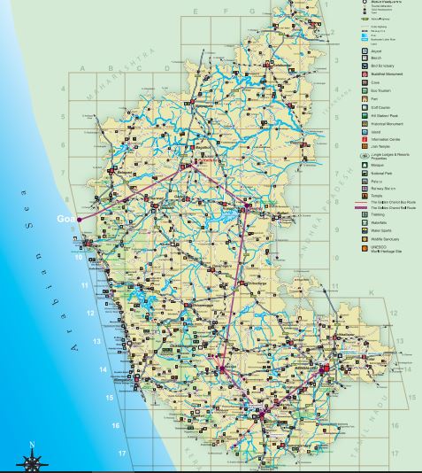
Karnataka Map
Jog Falls (C11)
Bear witness to nature’s headlong tumble as the Sharavati River takes a spectacular drop of 830 ft. in four distinct cascades to create the highest untiered waterfall in India.
Shivanasamudra Falls (I16)
Discover nature’s handiwork in the form of this tiny island town, 65km southeast of Mysuru.
Here the Cauvery River plummets from a height of 75 m into a rocky gorge with a deafening roar.
It is also home to Asia’s first hydroelectric project.
Irrupu Falls (F17)
Nestling beside the Nagarahole National Park, Irrupu Falls presents a stunning sight during the monsoons. The falls plunge 170 ft. in two distinct stages.
The ceaseless music of the falls and the hush of the densely wooded forest make this a great picnic spot.
Unchalli Falls (C11)
A 5 km trek from Heggarne, a dreamy hamlet in Uttara Kannada District, through dense forests, brings you to the picturesque Unchalli Falls.
The sound of the cataract hurtling down the hilly tract shatters the silence of the forests, making it an unforgettable sight.
Gokak Falls (C6)
65 km from Belgaum, the Ghataprabha takes a 170ft. leap over a rocky bed.
The falls get their name from the Goki trees that abound here.
Hebbe Falls, Abbey Falls, Kalhatti Falls, Also visit: Magod Falls, Sathodi Falls & Lalguli Falls.
Karwar (A10)
With gentle waves, miles of golden sand, rugged hill ranges, thick woods and acres of emerald foliage, Karwar has all the makings of a perfect holiday destination.
It also inspired the great Indian poet Rabindranath Tagore to pen his first play.
Gokarna (B10)
This coastal town draws Hindu pilgrims, Sanskrit scholars and beach buffs alike.
Visit Om beach, which is in the shape of ‘Om’, a spiritual symbol.
The other beaches, wedged between gigantic cliffs protrude like delicate fingers into the sea.
Kaup (C13)
Situated 12 km south of Udupi, on the coastal belt that passes through the West Coast National Highway, Kaup has a lovely beach, a ruined fort and an old 100 ft. high lighthouse.
The two temples of Goddess Mariamma and the Jain Basadis here, though in ruins, are worth visiting.
Malpe
Maple is an important fishing centre that enriches Karnataka’s coastline with its fabulous beach.
The endless stretch of golden sand, graciously swaying palm trees, clear blue skies and the gentle murmur of the sea set the perfect mood for an idyllic holiday.
| Author | – |
| Language | English |
| No. of Pages | 2 |
| PDF Size | 1 MB |
| Category | Geography |
| Source/Credits | karnatakatourism.org |
Related PDFs
Indian Geography Notes PDF For Exams
Africa Continent Political And Physical Map PDF
Mahesh Kumar Barnwal Geography Book PDF In Hindi
District Map of Karnataka State PDF Free Download