‘India Political Map’ PDF Quick download link is given at the bottom of this article. You can see the PDF demo, size of the PDF, page numbers, and direct download Free PDF of ‘India Political Map’ using the download button.
New India Political Map PDF Free Download
Indian Political Map Details
Area
The distance from the country’s northern border to its southern coastline is 2,930 km (1,820 mi), and from the west coast of Gujarat to the border with Bangladesh in the east 2,040 km (1,267 mi).
India covers an area of 3,287,263 km², making it the 7th largest country in the world, compared it is about 45% of the size of Australia, about 40% the size of the contiguous USA, or one third the size of Europe.
Population
India is the second most populated country on the planet. 1.36 billion people (in 2019), almost one-fifth of the world’s population, live on the Indian subcontinent.
India’s population is quite diverse with two thousand ethnic groups, four major language families, and more than 120 languages, however, more than 40% of the Indians speak Hindi, besides English, both official languages of the country.
Here we give a link to download various maps of India.
You can download the Indian political map with all states and union territories with their capital.
And, you can download the outline map(Blank Map) and do print and use it for study purposes and make a map by your own self.
Survey of India also provides map JPG formate image in three languages Hindi, English, And Sanskrit, that you can download from the below link.
And another map includes National roads and railway connections which give you a good idea about connectivity.
India is located in southern Asia. It is bordered by the Arabian Sea, Laccadive Sea, and the Bay of Bengal to the south; Bhutan, Nepal, China, and Pakistan to the north; and Bangladesh and Myanmar (Burma) to the east.
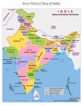
The India Political map shows all the states and union territories of India along with their capital cities. It comprises a total of 28 states along with eight union territories.
India is officially known as the Republic of India. It comprises a total of 28 states along with eight union territories.
India is the second most populated country in the world and the world’s largest democracy.
The country’s coastline measures 7,517 kilometers in length, out of which 5,423 kilometers belong to peninsular India, and 2,094 kilometers belong to Andaman, Nicobar, and Lakshadweep island chains.
Additionally, the Indian naval hydrographic charts along with mainland coastline include 43% of sandy beaches, 36% of mudflats, marshy shores of 10%, and rocky shores of 11%.
Broadly, India is divided into six major zones: East India, West India, North India, South India, Northeast India, and Central India.
Eastern India includes the states of Bihar, Jharkhand, Odisha, West Bengal, and a union territory Andaman and Nicobar Islands. The total population of these states is 226,925,195.
The Eastern zone covers a total area of 418,323 sq km Bengali is the dominant language in the state of West Bengal.
In contrast, Odia and Hindi are the principal languages in the states of Odisha, Bihar, and Jharkhand. English, Maithili, Nepali, and Urdu are other languages spoken in Eastern India.
The Western region of India covers a total area of 508, 052 sq km Some of the popular states of western India are Gujarat, Goa, and Maharashtra Union Territory of Dadra & Nagar Haveli, and Daman & Diu.
Mumbai, the financial capital of India, is the capital city of Maharashtra. The states of western India have a prosperous economy with a relatively high standard of living. Official languages of the Western Indian states are Marathi, Gujarati, Konkani, and English.
The five states of North India are Himachal Pradesh, Uttar Pradesh, Uttarakhand, Punjab, Haryana with union territories of Delhi (National Capital Territory), Chandigarh, Ladakh, and Jammu and Kashmir.
The economy of northern India is growing at a fast pace. The most populous cities of North India are New Delhi, Lucknow, and Chandigarh.
Southern India covers states like Tamil Nadu, Karnataka, Kerala, Andhra Pradesh, and Telangana with the union territories of Lakshadweep. and Puducherry.
Over 19.31% of India’s total area is occupied by these states and union territories. Bengaluru, the capital of Karnataka, is known as the ‘Silicon Valley of India’ because it is India’s leading exporter in the IT sector.
The most populated cities of South India are Bengaluru, Hyderabad, Chennai, Coimbatore, Cochin, and Mysore.
Northeast India includes the seven sister states of Arunachal Pradesh, Assam, Meghalaya, Tripura, Mizoram, Manipur, and Nagaland.
The Himalayan state of Sikkim and Jalpaiguri Division are two important parts of northeast India. There is a great ethnic and religious diversity within the seven sister states. The Central zone of India primarily refers to Madhya Pradesh and Chhattisgarh.
| States and Capitals of India 2023 | |||
|---|---|---|---|
| S. No | States Name | Capital | Founded on |
| 1 | Andhra Pradesh | Hyderabad (Proposed Capital Amaravati) | 1 Nov. 1956 |
| 2 | Arunachal Pradesh | Itanagar | 20 Feb. 1987 |
| 3 | Assam | Dispur | 26 Jan. 1950 |
| 4 | Bihar | Patna | 26 Jan. 1950 |
| 5 | Chhattisgarh | Raipur | 1 Nov. 2000 |
| 6 | Goa | Panaji | 30 May. 1987 |
| 7 | Gujarat | Gandhinagar | 1 May. 1960 |
| 8 | Haryana | Chandigarh | 1 Nov. 1966 |
| 9 | Himachal Pradesh | Shimla | 25 Jan. 1971 |
| 10 | Jharkhand | Ranchi | 15 Nov. 2000 |
| 11 | Karnataka | Bengaluru (formerly Bangalore) | 1 Nov. 1956 |
| 12 | Kerala | Thiruvananthapuram | 1 Nov. 1956 |
| 13 | Madhya Pradesh | Bhopal | 1 Nov. 1956 |
| 14 | Maharashtra | Mumbai | 1 May. 1960 |
| 15 | Manipur | Imphal | 21 Jan. 1972 |
| 16 | Meghalaya | Shillong | 21 Jan. 1972 |
| 17 | Mizoram | Aizawl | 20 Feb. 1987 |
| 18 | Nagaland | Kohima | 1 Dec. 1963 |
| 19 | Odisha | Bhubaneswar | 26 Jan. 1950 |
| 20 | Punjab | Chandigarh | 1 Nov. 1956 |
| 21 | Rajasthan | Jaipur | 1 Nov. 1956 |
| 22 | Sikkim | Gangtok | 16 May. 1975 |
| 23 | Tamil Nadu | Chennai | 26 Jan. 1950 |
| 24 | Telangana | Hyderabad | 2 Jun. 2014 |
| 25 | Tripura | Agartala | 21 Jan. 1972 |
| 26 | Uttar Pradesh | Lucknow | 26 Jan. 1950 |
| 27 | Uttarakhand | Dehradun (Winter), Gairsain (Summer) | 9 Nov. 2000 |
| 28 | West Bengal | Kolkata | 1 Nov. 1956 |
| Union Territories and Capitals | |||
| Union Territories Names | Capital | Founded on | |
| 29 | Andaman and Nicobar Islands | Port Blair | 1 Nov. 1956 |
| 30 | Chandigarh | Chandigarh | 1 Nov. 1966 |
| 31 | Dadra & Nagar Haveli and Daman & Diu | Daman | 26 Jan. 2020 |
| 32 | Delhi | New Delhi | 9 May. 1905 |
| 33 | Jammu and Kashmir | Srinagar (Summer) , Jammu (Winter) | 31-Oct-19 |
| 34 | Lakshadweep | Kavaratti | 1 Nov. 1956 |
| 35 | Puducherry | Pondicherry | 1 Nov. 1954 |
| 36 | Ladakh | Leh | 31-Oct-19 |
| Author | – |
| Language | English |
| No. of Pages | 2 |
| PDF Size | 0.44 MB |
| Category | Government |
| Source/ Credits | ismandovi.in |
Blank Political Map of India with white background for student and you can also print it out
Download Blank Printable Map PDF, Click Here
Related PDFs
India Political Map PDF Free Download