‘Bangalore Metro Map’ PDF Quick download link is given at the bottom of this article. You can see the PDF demo, size of the PDF, page numbers, and direct download Free PDF of ‘Bangalore Metro Map’ using the download button.
Bangalore Metro Map PDF Free Download
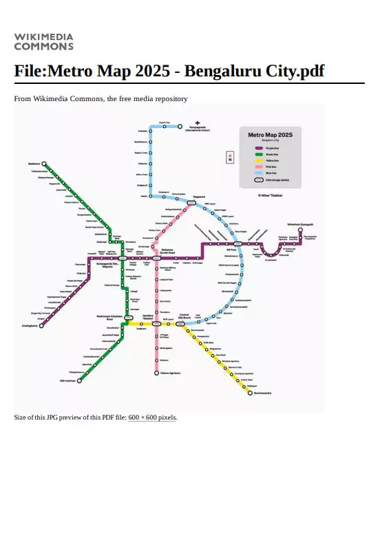
Bangalore Metro Map
The Bangalore Metro, operated by the Bangalore Metro Rail Corporation Limited (BMRCL), is also known as Namma Metro in Kannada, meaning “our metro”.
The length of this entire network system of 51 stations is 56.1 km. The average speed of the metro is 36 km/h and the maximum speed is 80 km/h.
This rapid transit system is divided into color line numbers.
Purple Line – 1
This line connects Baiyyappanahalli in the east of Bangalore to Kengeri station in the southwest. The total length of Purple Line-1 is 25.7 km, with a total of 22 stations.
Green Line – 2
Green Line – 2 connects Nagasandra in the northwest to Silk Institute in the southwest. The entire network is 30.4 km with a total of 30 stations.
Information about other future lines
The entire metro network system was divided into Phase 1, Phase 2, Phase 2A, and Phase 2B (Airport Line), in which Phase 1 work has been completed. But still, the work of the remaining phase is going on.
| Language | English |
| No. of Pages | 5 |
| PDF Size | 0.06 MB |
| Category | General |
| Source/Credits | – |
Related PDFs
Bangalore Metro Map PDF Free Download