‘River Map Of India’ PDF Quick download link is given at the bottom of this article. You can see the PDF demo, size of the PDF, page numbers, and direct download Free PDF of ‘Indian River Map’ using the download button.
Indian/Bharat Rivers Map PDF Free Download
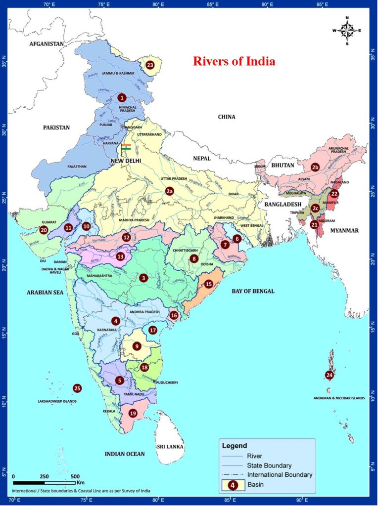
All Indian River Map For Student
The rivers of India play an important role in the lives of the Indian people. The river systems provide irrigation, potable water, cheap transportation, electricity, as well as provide livelihoods for a large number of people all over the country.
This easily explains why nearly all the major cities of India are located by the banks of rivers.
The rivers also have an important role in Hindu mythology and are considered holy by all Hindus in the country.
Seven major rivers (Indus, Brahmaputra, Narmada, Tapi, Godavari, Krishna, and Mahanadi )along with their numerous tributaries make up the river system of India.
Most of the rivers pour their waters into the Bay of Bengal. Some of the rivers whose courses take them through the western part of the country and towards the east of the state of Himachal Pradesh empty into the Arabian Sea.
Parts of Ladakh, northern parts of the Aravalli range, and the arid parts of the Thar Desert have inland drainage.
All major rivers of India originate from one of the three main watersheds.
- The Himalaya and the Karakoram ranges
- Vindhya and Satpura ranges and Chotanagpur plateau in central India
- Sahyadri or Western Ghats in western India
Code And Rives Basin In PDF
| Code | Basin Name |
| 1 | Indus (Up to border) |
| 2a | Ganga |
| 2b | Brahmaputra |
| 2b | Barak and others |
| 3 | Godavari |
| 4 | Krishna |
| 5 | Cauvery |
| 6 | Subernarekha |
| 7 | Brahmani and Baitarni |
| 8 | Mahanadi |
| 9 | Pennar |
| 10 | Mahi |
| 11 | Sabarmati |
| 12 | Narmada |
| 13 | Tapi |
| 14 | West flowing rivers South of Tapi |
| 15 | East flowing rivers between Mahanadi and Godavari |
| 16 | East flowing rivers between Godavari and Krishna |
| 17 | East flowing rivers between Krishna and Pennar |
| 18 | East flowing rivers between Pennar and Cauvery |
| 19 | East flowing rivers South of Cauvery |
| 20 | West flowing rivers of Kutch and Saurashtra including Luni |
| 21 | Minor rivers draining into Bangladesh |
| 22 | Minor rivers draining into Myanmar |
| 23 | Area of North Ladakh not draining into Indus |
| 24 | Drainage Area of Andaman & Nicobar Islands |
| 25 | Drainage Area of Lakshadweep Islands |
Indian Major Rivers Information
| River | Length (km) | Length (miles) | Drainage area (km²) | Outflow | Countries in the drainage basin | India Regions in the drainage basin |
|---|---|---|---|---|---|---|
| Brahmaputra | 2900 | 1800 | 651334 | Bay of Bengal | India, Tibet (Autonomous Region of China), Bangladesh | Assam, Arunachal Pradesh |
| Indus | 2900 | 1800 | 1165000 | Arabian Sea | Pakistan, India, Tibet (Autonomous Region of China) | Jammu and Kashmir |
| Ganges | 2510 | 1560 | 1080000 | Bay of Bengal | India, Bangladesh | Uttarakhand, Uttarpradesh, Bihar, Jharkhand, West Bengal |
| Satluj | 1400 | 900 | 66317 | Confluence with Chenab | India, Tibet (Autonomous Region of China), Pakistan | Himachal Pradesh, Punjab |
| Godavari | 1465 | 910 | 312812 | Bay of Bengal | India | Maharashtra, Andhra Pradesh |
| Yamuna | 1376 | 855 | 366223 | Ganges | India | Delhi, Uttar Pradesh, Haryana, Uttarakhand |
| Krishna | 1327 | 825 | 258948 | Bay of Bengal | India | Maharashtra, Karnataka, Andhra Pradesh |
| Narmada | 1312 | 815 | 98796 | Gulf of Khambat | India | Madhya Pradesh, Gujrat |
| Ghagra | 1080 | 670 | 127950 | Ganges | India, Tibet (Autonomous Region of China), Nepal | Bihar |
| Cauvery | 765 | 475 | 72000 | Bay of Bengal | India | Karnataka, Tamil Nadu |
| Author | – |
| Language | English |
| No. of Pages | 1 |
| PDF Size | 0.3 MB |
| Category | Geography |
The Yamuna is the most polluted river in India.
The Ganga is the largest river in India.
Related PDFs
S.Y.B.A. Marathi Question PDF For University Student
River Map Of India PDF Free Download